Pre-pyrenean Trail. 11 stages
Pre-pyrenean trekkinig

Pre-pyrenean trekkinig with luggage transfer
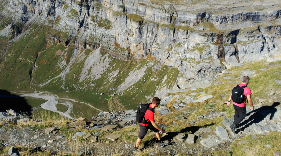
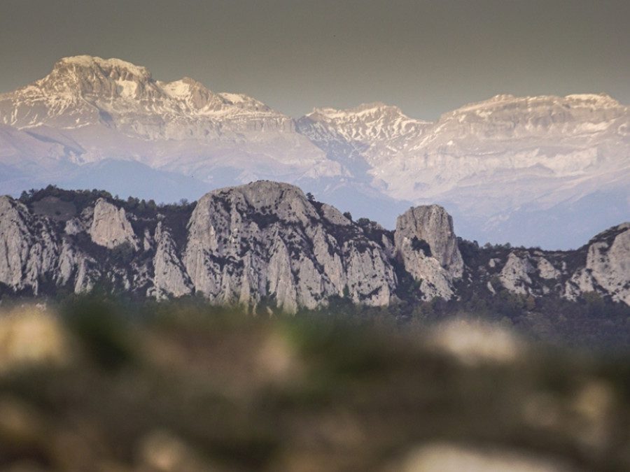
Prepirenaica is the great tour going through the Aragonese Southern Pyrenees from west to east, passing by the best natural areas of Sierra de Santo Domingo, Reino de los Mallos and Sierra de Guara ranges. An extremely beautiful journey where you’ll get to experience the natural and cultural wonders of this privileged and diverse area. A trail that connects ancient villages going through a series of remote areas where medieval treasures are hidden. On this journey, you will enjoy unique landscapes characterized by deep gorges, green prairies and 400 meters high conglomerate and limestone walls. A trail that every hiker and trail runner must experience. Are you ready for Prepirenaica Trail? Enjoy!
Choose the seven stages that you most want. They do not have to be consecutive. Call us and we will advise you.
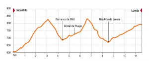
Stage 1: Uncastillo – Luesia
Today we will discover the extraordinary and monumental territory of Cinco Villas, where the first three stages of this spectacular tour take place. Today we will enjoy some of the wonderful landscapes that will be around during the first three stages, as well as some of the most representative monumental heritage of this land.
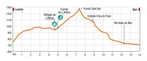
Stage 2: Luesia – Biel
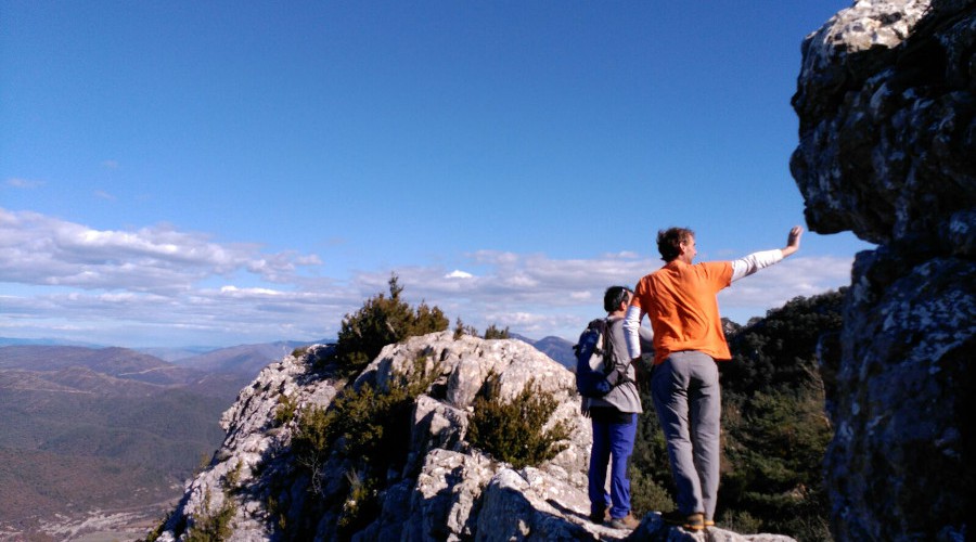
Today we get into Sierra de Santo Domingo, a magical natural environment where fabulous oak and beech forests and peculiar conglomerate and limestone formations will offer a great experience as well as the chance of getting wonderful pictures. This mountain range is a privileged natural area. Enjoy it!
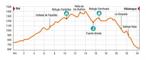
Stage 3: Biel – Villalangua
This is probably the best stage of Sierra de Santo Domingo. A very spectacular and long trail getting into a privileged natural area full of deep and narrow ravines, rocky ridges, deep forests and peaceful prairies. A wonderful journey through a wild no man’s land where forgotten trails continuously give us beautiful panoramas.
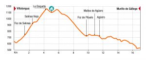
Stage 4: Villalangua – Murillo de Gállego
Espectacular etapa en la que nos adentramos en el Reino de los Mallos. Remontando la Foz de Salinas hasta el paso de la Osqueta para descender entre los Mallos de Aguero. Terminamos a las orillas del bravo río Gállego con esplendidas vistas a los Mallos.
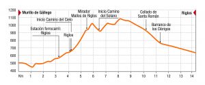
Stage 5: Murillo de Gállego – Riglos
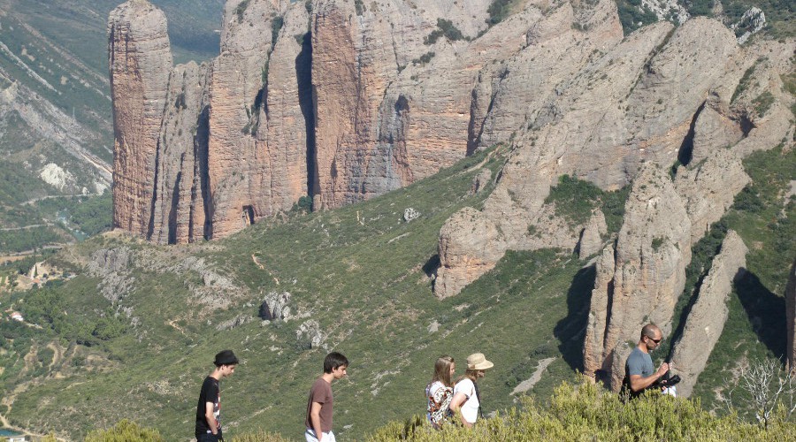
Today we walk across the streets and vertical walls of Foz de Salinas, passing by Fuente de la Tosca de la Rata waterfall and the uninhabited village of Salinas Viejo. We will climb to the Col De la Osqueta, an exceptional mirror where you’ll enjoy an overwhelming panoramic view of the Pyrenees. On the descent to Agüero we will visit Foz de Pituelo and its stunning limestone cliffs and mysterious caves, before descending to this beautiful medieval village, located on the foothills of the impressive conglomerate walls of Mallos de Agüero, recently appointed Natural Monument.
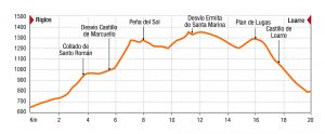
Stage 6: Riglos – Loarre
Switch on your camera and get ready to have an unforgettable experience discovering the natural wonders of Sierra de Loarre and its ancient heritage by visiting Loarre Castle and the medieval ensemble of Marcuello. Today we leave Mallos de Riglos to ascend Collado de Santo Román, close to the nearby Mirador de los Buitres and the medieval castle and hermitages of Marcuello, located over the cliffs of Os Fils.
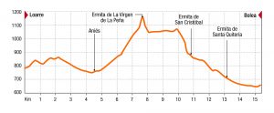
Stage 7: Loarre – Bolea
Today we get into the universe of prehistoric hermitages, often nestled on rocky outcrops, remarkable spots where nature and cultural heritage merge. We’ll visit the cozy village of Aniés, before ascending through a path that gets into deep forests and limestone walls to the hermitage of Virgen de la Peña, surprisingly located into a hollow formed by the nearby limestone walls.
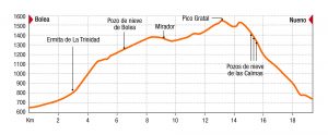
Stage 8: Bolea – Nueno (alternative 1: Arguis)
oday we get into Sierra de Caballera and Sierra de Gratal ranges to ascend a remarkable summit like Peña Gratal (1,543 m.). We’ll also discover ancient ice wells. These constructions, excavated in the soil at depths of up to 5 meters and finished in masonry, were common in Southern Pyrenees. Today you’ll know how they were built and what they were used for.
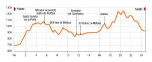
Stage 9: Nueno – Nocito (alternative 1: Arguis)
Today we get into western Sierra y los Cañones de Guara Natural Park by visiting some of its most beautiful spots like the overwhelming Salto de Roldán, the vertical cliffs of Cienfuens and the beautiful valleys of Belsué and Nocito.
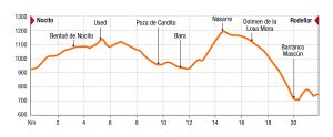
Stage 10: Nocito – Rodellar
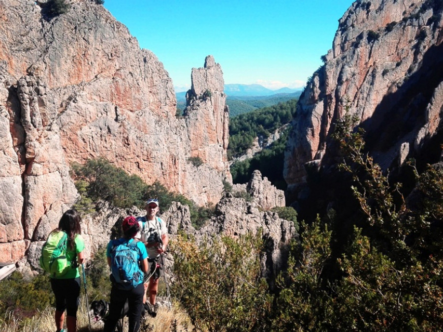
Today we will get into one of the wildest areas of Southern Pyrenees, visiting some of the most beautiful uninhabited villages of Nocito Valley as well as the deep Mascún Canyon, one of the most spectacular ravines of Sierra de Guara.
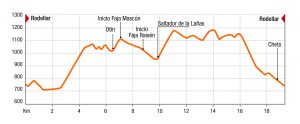
Stage 11: Rodellar – Rodellar
The tour of Mascún Canyon is one of the best hiking routes of Prepyr365 and the entire Sierra de Guara. For that reason, we’ll get again into this impressive canyon, this time to visit the amazing La Costera’s landscape and the spectacular and vertical trails of Mascún and Raisén leading to the magical waterfall Saltador de las Lañas, the starting point for the canyoning descent.
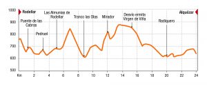
Stage 12: Rodellar – Alquézar
Today we’ll discover the turquoise water ravines of Alcanadre River as well as Arangol and Balced mountain ranges, from where we’ll obtain excellent panoramic views of Cabezo de Guara and Tozal de Guara (2,077 m) summits. Located in the heart of Sierra y Cañones de Guara Natural Park and nestled on Vero River ravine, the wonderful and inspiring medieval village of Alquézar, rewarded as one of the most beautiful villages of Spain, guarantees the right end to the final stage of the tour.
What’s included:
- Welcome at the start of the route
- Half board accommodation
- Transfer from Luesia to Alquézar
- Daily luggage transfer
- A guidebook with topo and a map and the GPS tracks
- Support vehicle and professinal guide (optinal)
- Insurance (optional)
What’s not included:
- Drinks and lunches
- Anything not listed above under “What’s included”
Accommodations available:
- This trip is available all year although from March to November the weather is more favorable. In summer you must start early and to rest and bathing in natural pools at midday.
- You can fill out a form to customize your trip or hire extra services: Rent a gps, insurance, Support vehicle…
- Prices are calculated for a group of four people.
Difficulty:
Stage 1: Ficha técnica
 One-Way trail 11,3 km , +470 m
- Terrain: Unpaved road, path
- Estimated time: 3 h
- Difficulty: Technical Medium Physical: Low
Stage 2: Ficha técnica

- One-Way trail 14 km, +650 m
- Terrain: path
- Estimated time: 4 h
- Difficulty: Technical Medium Physical: Medium
Stage 3: Ficha técnica
 One-Way trail 24 km, + 980 m
- Terrain: path
- Estimated time: 9-10 h
- Difficulty: Technical Medium Physical: Very high
Stage 4: Ficha técnica
 One-Way trail 17,2 km, + 700 m
- Terrain: Unpaved road, path
- Estimated time: 5-6 h
- Difficulty: Technical Medium Physical: Medium
Stage 5: Ficha técnica
 One-Way trail 14,2 km, + 840 m
- Terrain: Unpaved road, path
- Estimated time: 6-7 h
- Difficulty: Technical Medium Physical: Medium
Stage 6: Ficha técnica
 One-Way trail 20,1 km, + 950 m
- Terrain: Unpaved road, path
- Estimated time: 7-8 h
- Difficulty: Technical: Medium Physical: High
Stage 7: Ficha técnica
 One-Way trail 15,6 km, + 635 m
- Terrain: Unpaved road, path
- Estimated time: 5-6 h
- Difficulty: Technical Medium Physical: Medium
Stage 8: Ficha técnica
 One-Way trail 19,4 km, + 960 m
- Terrain: Unpaved road, path
- Estimated time: 7-8 h
- Difficulty: Technical High Physical: Medium
Stage 9: Ficha técnica
 One-Way trail 24,5 km, + 1150 m
- Terrain: path
- Estimated time: 9-10 h
- Difficulty: Technical Medium Physical: Very high
Stage 10: Ficha técnica
 One-Way trail 21,9 km, + 630 m
- Terrain: Unpaved road, path
- Estimated time: 7-8 h
- Difficulty: Technical Medium Physical: High
Stage 11: Ficha técnica
 One-Way trail 19,7 km, + 1150 m
- Terrain: path
- Estimated time: 8-9 h
- Difficulty: Technical High Physical: Very high
Stage 12: Ficha técnica
—
Practical tips:
Recommendations
Prepirenaica Trail is a self-guided hiking and trail running tour, designed to be done with a GPS device and the support of materials provided through this website.
Prepirenaica Trail is not marked, although many of its sections are part of other local trails so they marked with distinctive signs. However, there is not a common signaling.
Trails are usually well preserved but their conditions can change from one stage to another. In case of finding a section in poor condition please, contact us!
In many sections, there is not mobile coverage. Remember that the phone number in case of emergencies is 112.
Prepirenaica Trail can be done all year round, although in the summer season temperatures can be high. Try to plan the stage avoiding noon. It is recommended to get up early and finish the stage before 13 h.
Prepirenaica Trail requires a user level of GPS management. In case you do not have it, it is recommended to hire a qualifies guide. Check Prepyr services on this website.
There are opened mountain shelters that can be used for overnight stays. If you decide to use the, please, respect the rules of use and remember to leave it as you found it.
Remember the practical advice of security of the Aragonese Mountain Federation:
- Avoid hiking alone.
- Equipment must be in perfect conditions of use.
- Save strength for the way back. Never hurry up the mountain.
- Use maps and books. If you have no experience hire qualified guides.
- First aid courses teach you how to prevent and act in case of accident.
- Check weather forecasts
- Calculate the planned schedule and distances
- Prepare an alternative plan in case you must shorten the activity
- Equip your backpack before going on a trip
—
Useful information:
- EU citizens should bring a European Health Insurance Card (EHIC) from their home country, or take out prívate medical insurance.
- Non-EU citizens will need a passport and visas.
- All excursions are guaranteed with a mínimum of four people.
Activities:
—
Personal attention:
—
Accommodation options:
Pre-pyrenean Trail. 11 stages
Pre-pyrenean trekkinig
Pre-Pyrenees
Crossings on foot and on horseback | Nordic walking | Trail running | Trekking
Duration:
Level:
Season:
Consultar
What’s different about us
You may also be interested...
Trekking in pyrenees
La Senda de Camille 7 stages
Pyrenees
Crossings on foot and on horseback · Nordic walking · Trekking
Nivel:
Temporada:
desde
€
Self-guided trekking routes “Destination Murillo”
Pre-Pyrenees
Castles and fortresses · Crossings on foot and on horseback · Romanic · Thematic tours · Traveling with children · Trekking · Wine routes
Nivel:
Temporada:
desde
€
GR-1 The historic trail in north Spain. 1 week hiking holidays
Pre-Pyrenees
Crossings on foot and on horseback · Trail running · Trekking
Nivel:
Temporada:
desde
€
